top of page

BOWERS DRONES

Our Services

Construction Progress Report

Keep your project on track with high-resolution aerial imagery that documents every phase of construction, verifies site progress, and provides measurable updates for your team and clients.

Aerial drone mapping of a construction site foundation in Northwest Arkansas showing precise area measurements and progress tracking data.
Professional drone stockpile volume measurement and cut and fill analysis for construction sites in Northwest Arkansas by Bowers Drones.

Stockpile Volume Measurement - Cut & Fill Analysis

Leverage RTK-enabled drone mapping and software to generate precise stockpile volume measurements and accurate cut-and-fill analysis.

Asset & Infrastructure Inspection

High resolution aerial inspections that capture detailed imagery of roofs, facades, utilities, and infrastructure - helping teams identify issues early and plan maintenance before issues arise.

High-resolution commercial roof and facade inspection in Northwest Arkansas by Bowers Drones to identify infrastructure maintenance needs early.

360° Virtual Walkthroughs

This mission creates immersive 360° virtual tours of residential, commercial, and construction spaces, using high-resolution panoramic imagery. We capture both exterior and interior environments, allowing viewers to explore sites remotely.

Immersive 360-degree virtual walkthrough and panoramic drone imagery for residential and commercial construction sites in Northwest Arkansas by Bowers Drones.

Aerial Marketing & Real Estate

Our Aerial Marketing & Real Estate missions produce aerial visuals that highlight properties, developments, and commercial spaces.

Professional real estate drone photography of a luxury lakefront home in Northwest Arkansas by Bowers Drones for high-end property marketing.
Aerial drone cinematography of the scenic Northwest Arkansas landscape and lake at sunset by Bowers Drones for nature and landscape projects.
3D drone model and digital twin of a quarry and industrial site in Northwest Arkansas by Bowers Drones for high-precision site measurements and mapping.

ABOUT US

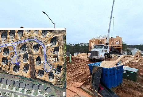
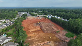
Bowers Drones is a veteran and first responder owned company delivering professional aerial imaging and data solutions for construction, inspection, and other commercial applications.

Founded by brothers Brock and Bailey Bowers in 2023, both with backgrounds in the military and law enforcement, the company brings reliability, discipline, and technical precision to every mission.

We have been fortunate to fly missions across the Midwest and the South, with missions including large-scale residential and commercial developments, warehouse inspections, and promotional aerial media.

We are now based in Northwestern Arkansas and deliver FAA certified drone services that are sure to exceed your expectations. We look forward to working with you!

Frequently asked questions

bottom of page